
Met Office Issues Yellow Warning as Thunderstorms Set to Strike Across Britain
Current Weather Alert Status
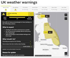
The Met Office has issued a yellow thunderstorm warning as parts of the UK face the threat of lightning and hail, with storms expected across areas in England and Wales.
Weather Pattern Development
The current period is marked by unsettled conditions with low pressure dominating the pattern. This is bringing showers or longer spells of rain affecting most of the UK, with heavy rainfall particularly affecting western and northern regions. The situation is further complicated by the possibility of thunderstorms and hail, along with spells of strong winds.
Expert Analysis
According to Rebekah Hicks, Chief Meteorologist at the Met Office, a band of heavy rain and strong winds is moving northeast, followed by heavy showers and thunderstorm risk. These weather events could bring hail and gusty winds, particularly in southern areas. The timing is particularly significant as it coincides with the first school run after summer holidays for some regions.
Expected Impacts
The Met Office distinguishes between regular rain and thunderstorm impacts: while rain typically lasts for hours or days and may result in river flooding, thunderstorms are characterized by shorter periods of heavy or intense rain, which can lead to rapid surface water flooding.
Looking Ahead
Later in the period, there are indications of longer spells of drier weather developing, especially towards the south, with increased sunshine due to higher pressure. Temperatures are expected to remain close to average or slightly below overall, though they may rise above average during drier, sunnier spells.
Safety Advice
The Met Office advises the public to keep up to date with weather warnings through their website, social media channels, and mobile app. Special care should be taken when travelling in heavy rain, wind, and thunderstorms.