
Met Office Issues Snow and Ice Warnings as Arctic Blast Grips the UK
Introduction: Cold Spell Brings Winter Weather to Britain
The United Kingdom has entered 2026 with a significant cold snap, as Arctic air sinks south to cover the whole country. The Met Office has issued UK weather warnings for rain, wind, snow, ice, fog, thunderstorm, lightning and extreme heat, with particular focus on snow and ice hazards expected to cause disruption across multiple regions. This weather event marks the first snow of the winter for many areas, making it crucial for residents to stay informed and prepared.
Current Weather Warnings and Affected Areas
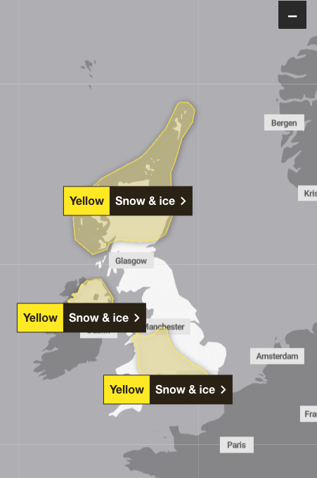
Yellow warnings for snow and ice are in place in the Scottish Highlands, extending into much of the west side of England and Wales, stretching down below East Anglia but covering London and Kent. These warnings will be in place from 8pm on December 31 until 10am on January 6. According to the Met Office, frequent and heavy snow showers may lead to some travel disruption, with warnings of injuries due to slips and falls on icy surfaces.
Temperatures will fall well below average, with snow showers and snow accumulations likely, particularly in northern and some central areas. Very cold temperatures will continue through Saturday and Sunday, with minus double figures overnight and daytime temperatures not rising above 0°C for many areas. The forecaster has warned that on the highest routes and hills, 30cm of snow may build through the period, with drifting likely due to the strength of the wind.
Health Alerts and Public Safety Advice
The UK Health Security Agency (UKHSA) has issued amber cold health alerts for England until January 6. The UKHSA said the weather is likely to cause significant impacts across health and social care services, including a rise in deaths among those with health conditions or aged 65 or over.
Transport officials are advising caution, with particularly cold weather expected to impact driving conditions in the areas covered by the yellow warning, with advice to plan journeys and leave extra time if needed. The Met Office recommends checking road conditions, public transport schedules, and keeping emergency supplies in vehicles during this period.
Looking Ahead: Extended Cold Spell Expected
Wintry hazards will continue, with more severe weather warnings possible, and this cold spell could last well into next week. These colder conditions and wintry hazards will develop more widely as we enter the new year, with more warnings for snow and ice likely, and this cold spell will last through at least the first week of January.
The Met Office urges the public to stay updated with the latest forecasts and warnings through their official channels. This early winter cold spell serves as a reminder of the importance of winter preparedness, particularly for vulnerable individuals and those planning to travel during this period.