
UK Snow Storm Weather Forecast: Storm Goretti Brings Severe Winter Conditions
Introduction: Why UK Snow Storm Forecasts Matter Now
The United Kingdom is experiencing one of the most significant winter weather events in recent memory, with snow accumulations of 2-5cm at low levels and 10-20cm over higher ground causing ongoing disruption. Understanding snow storm weather forecasts has become crucial for millions of Britons as cold conditions bringing a range of wintry hazards are set to continue across the UK. With travel disruption, school closures, and health alerts in place, staying informed about weather patterns can help residents prepare and stay safe during this challenging period.
Storm Goretti: A Multi-Hazard Weather Event
Meteo France has named the low Storm Goretti, as the worst of the wind impacts are expected to be felt across northern France, but the UK has not been spared from its effects. Storm Goretti brought snow warnings for Wales, the Midlands, and northern England, with five to ten centimetres expected, and up to 20cm over higher ground. The storm has created dangerous conditions, with winds of almost 100mph after forecasters issued a rare red warning for dangerous, stormy winds in the South West.
Record-Breaking Cold and Snow Accumulation
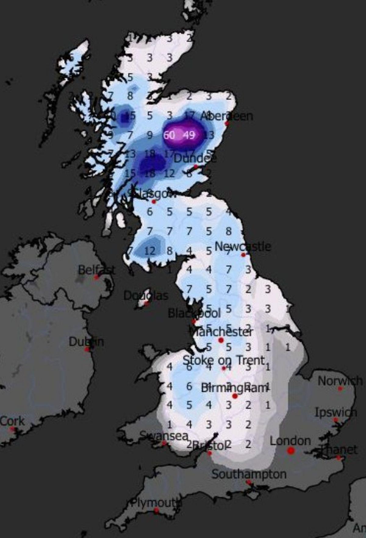
The current cold snap has produced remarkable temperature extremes across Britain. Temperatures fell to as low as -12.5°C in Marham, Norfolk, while Santam Downham in Suffolk, and Topcliffe, North Yorkshire, both saw a low of -10°C. Scotland has been particularly hard hit, with the greatest snow accumulations being 52cm at Tomintoul in Banffshire, 35cm at Durris in Kincardineshire and 34cm at Loch Glascarnoch. For northern Scotland, this has been one of the snowiest spells in living memory.
Ongoing Weather Warnings and Public Safety
A string of four Amber warnings for snow are in force across parts of the northern half of Scotland, complemented by numerous yellow warnings covering various regions. The disruption has been significant, with more than 38,000 properties without power in the South West at about 8pm on Friday, according to the National Grid’s website. The UK Health Security Agency has issued amber cold health alerts for England, warning vulnerable populations about the health risks associated with prolonged cold exposure.
Looking Ahead: Transition to Milder Conditions
While the immediate forecast remains challenging, meteorologists indicate a gradual shift is coming. Later in the period, there is an increased chance that conditions will turn colder, with the potential transition to colder weather also increasing the chance of snow across parts of the country. However, temperatures will return closer to average for most through next week, with a south-westerly regime dominant. The transition period itself poses additional hazards, with a risk of some freezing rain for a time, especially across parts of east Scotland and northeast England, which could lead to ice forming very quickly on all surfaces.
Conclusion: Staying Weather-Ready
The current snow storm weather forecast for the UK underscores the importance of preparation and vigilance during severe winter conditions. As the nation navigates through Storm Goretti’s aftermath and anticipates further weather challenges, residents must stay informed through official Met Office updates and heed all weather warnings. The combination of heavy snow, freezing temperatures, strong winds, and potential flooding makes this a particularly complex weather situation requiring careful attention from all affected communities. By monitoring forecasts regularly and taking recommended safety precautions, Britons can better protect themselves and their families during this significant winter weather event.