
Weather Warnings for Snow Grip the UK as Arctic Air Brings Severe Winter Conditions
Arctic Air Descends on the United Kingdom
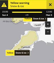
The United Kingdom is experiencing a significant weather event as amber and yellow National Severe Weather Warnings have been issued for snow and ice as Arctic air brings a prolonged spell of very cold weather for the start of 2026. Weather warnings for snow have become a critical concern for residents, commuters, and transport operators across the nation as conditions deteriorate rapidly.
Cold Arctic air now covers most of the UK, with temperatures well below average, widespread frost and ice and an increasing risk of snow showers. The Met Office has warned that further accumulations of 10-15cm are likely at low levels with 20-30cm possible on high ground, whilst strong winds will also result in drifting of snow and temporary blizzard conditions.
Impact on Daily Life and Transport
The severe weather warnings for snow are already causing significant disruption across multiple sectors. Colder air is moving south across the UK today, bringing a marked drop in temperatures, severe gales in the north, and an increasing risk of snow and ice. Transport networks face particular challenges, with roads, rail services, and bus routes all vulnerable to delays and cancellations.
Heavy snow showers across northern and northeast Scotland today have been particularly severe, whilst snow is expected to settle on the ground in some areas particularly in northern and some central areas. Health officials have also raised concerns, with the UK Health Security Agency (UKHSA) issuing amber cold health alerts for England until January 6.
What This Means for You
Understanding weather warnings for snow is essential for staying safe during this period. The Met Office advises the public to prepare for extended cold conditions, as very cold temperatures will continue through Saturday and Sunday, with minus double figures overnight and daytime temperatures not rising above 0°C for many areas.
Looking ahead, the recent spell of cold, northerly winds should begin to ease by the middle of next week, with snow showers in the north and east becoming lighter and less frequent. However, bands of rain seem likely to gradually move in off the Atlantic and, as these encounter the cold air entrenched over the UK, some further snowfall is possible. Residents are urged to monitor official weather warnings regularly, check on vulnerable neighbours, and avoid unnecessary travel during the worst conditions.