
Winter Storm Warning: Snow, Sleet and Ice Expected Across North Texas
Introduction
Winter storm warning is a critical alert that signals significant winter weather capable of disrupting travel, infrastructure and daily life. The warning is relevant for residents and authorities in affected regions because it denotes a combination of hazards — snow, sleet, freezing rain, and blowing snow — that can produce hazardous conditions. Recent official notices show parts of North Texas under such a warning, illustrating how quickly weather systems can affect large populations.
Main details
What is a Winter Storm Warning?
According to emergency management guidance, a Winter Storm Warning is issued for a significant winter weather event that may include snow, ice, sleet or blowing snow, or a combination of these hazards. The label indicates conditions that are likely to be dangerous and warrant heightened preparedness.
North Texas outlook and timing
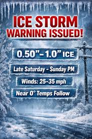
The National Weather Service has issued a Winter Storm Warning for North and Central Texas effective from 6 p.m. Friday through noon Sunday. Forecasts indicate wintry precipitation will impact all of North Texas from Friday night through Monday, with sleet, snow and freezing rain likely. Dallas–Fort Worth (DFW) has been highlighted for potential accumulations; reports note up to around 5 inches of snow and sleet possible in the DFW area. A full changeover to sleet and snow is expected across parts of North Texas late on Saturday before the precipitation ends on Sunday.
Hazards, locations and energy notes
Forecasters expect freezing rain and sleet to create dangerous ice across the region. North of the DFW metroplex — including Sherman, Paris and Graham — the sequence is expected to begin as rain and ice on Friday night, transitioning to sleet and snow on Saturday. In parallel, an Extreme Cold Warning is in effect from Saturday night into Monday morning for the region. The Electric Reliability Council of Texas (ERCOT) has warned that power outages may occur during the 2026 winter storm but expects the system to remain more stable than during the 2021 event.
Conclusion
The winter storm warning denotes a period of elevated risk for travel disruptions, hazardous icing and potential localized power interruptions across North Texas. The main impact window runs from Friday evening through Sunday midday, with the coldest conditions and changeover to snow expected late Saturday. Residents in affected areas should follow official updates and prepare for dangerous ice and wintry conditions during the warning period.